File:Mali map.png
From Wikimedia Commons, the free media repository
Jump to navigation
Jump to search
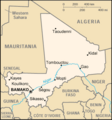
Mali_map.png (350 × 376 pixels, file size: 11 KB, MIME type: image/png)
File information
Structured data
Captions
Captions
Add a one-line explanation of what this file represents
carte du MALI

|
This locator map image could be re-created using vector graphics as an SVG file. This has several advantages; see Commons:Media for cleanup for more information. If an SVG form of this image is available, please upload it and afterwards replace this template with
{{vector version available|new image name}}.
It is recommended to name the SVG file “Mali map.svg”—then the template Vector version available (or Vva) does not need the new image name parameter. |
Summary
[edit]| DescriptionMali map.png |
English: Map of Mali |
| Date | |
| Source | https://www.cia.gov/library/publications/the-world-factbook/geos/ml.html |
| Author | CIA |
| This file is an original and may be obsolete for general use, but is kept for historical or archival use. As such, it should not be modified or deleted except to correct upload or technical errors. Any modified versions or replacements of this image should be uploaded with a different file name. Information about this file: 2004 version العربيَّة ∙ čeština ∙ Deutsch ∙ English ∙ español ∙ فارسی ∙ français ∙ magyar ∙ italiano ∙ 日本語 ∙ Lëtzebuergesch ∙ македонски ∙ മലയാളം ∙ Nederlands ∙ português ∙ русский ∙ slovenščina ∙ svenska ∙ 简体中文 ∙ 繁體中文 ∙ 正體中文(臺灣) ∙ +/− |
Licensing
[edit]| Public domainPublic domainfalsefalse |
| This image is a work of a Central Intelligence Agency employee, taken or made as part of that person's official duties. As a Work of the United States Government, this image or media is in the public domain in the United States.
čeština ∙ Deutsch ∙ eesti ∙ English ∙ español ∙ français ∙ italiano ∙ português ∙ polski ∙ sicilianu ∙ slovenščina ∙ suomi ∙ Tiếng Việt ∙ български ∙ македонски ∙ русский ∙ українська ∙ বাংলা ∙ മലയാളം ∙ 한국어 ∙ 日本語 ∙ 中文 ∙ 中文(简体) ∙ 中文(繁體) ∙ العربية ∙ پښتو ∙ +/− |

|
File history
Click on a date/time to view the file as it appeared at that time.
| Date/Time | Thumbnail | Dimensions | User | Comment | |
|---|---|---|---|---|---|
| current | 21:03, 3 March 2005 |  | 350 × 376 (11 KB) | Alfio (talk | contribs) | CIA map of Mali |
You cannot overwrite this file.
File usage on Commons
The following 6 pages use this file:
- Atlas of Mali
- Maps of Mali
- Índice de países
- File:Mali-CIA WFB Map (2004).png (file redirect)
- File:Mali.gif (file redirect)
- File:Ml-map.png (file redirect)
File usage on other wikis
The following other wikis use this file:
- Usage on als.wikipedia.org
- Usage on am.wikipedia.org
- Usage on ast.wikipedia.org
- Usage on ban.wikipedia.org
- Usage on bjn.wikipedia.org
- Usage on ca.wikipedia.org
- Usage on ceb.wikipedia.org
- Usage on da.wikipedia.org
- Usage on de.wikivoyage.org
- Usage on en.wikipedia.org
- Usage on es.wikipedia.org
- Usage on eu.wikipedia.org
- Usage on fa.wikipedia.org
- Usage on fi.wikipedia.org
- Usage on fo.wikipedia.org
- Usage on fr.wikipedia.org
- Usage on ha.wikipedia.org
- Usage on he.wikipedia.org
- Usage on hi.wiktionary.org
- Usage on hu.wikipedia.org
- Usage on hu.wiktionary.org
- Usage on id.wikipedia.org
- Usage on io.wikipedia.org
- Usage on ja.wikipedia.org
- Usage on jv.wikipedia.org
- Usage on ko.wikipedia.org
- Usage on mr.wikipedia.org
- Usage on nds.wikipedia.org
- Usage on nl.wikipedia.org
- Usage on no.wikipedia.org
- Usage on oc.wikipedia.org
- Usage on pl.wikipedia.org
- Usage on pt.wikipedia.org
View more global usage of this file.
