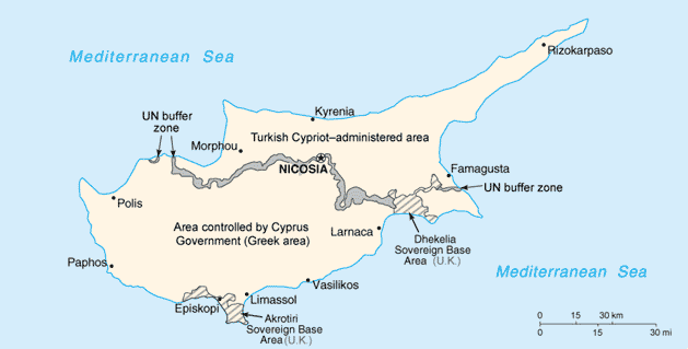
File:Cy-map.png
From Wikimedia Commons, the free media repository
Jump to navigation
Jump to search
Cy-map.png (629 × 319 pixels, file size: 12 KB, MIME type: image/png)
File information
Structured data
Captions
Captions
Add a one-line explanation of what this file represents

|
This map image could be re-created using vector graphics as an SVG file. This has several advantages; see Commons:Media for cleanup for more information. If an SVG form of this image is available, please upload it and afterwards replace this template with
{{vector version available|new image name}}.
It is recommended to name the SVG file “Cy-map.svg”—then the template Vector version available (or Vva) does not need the new image name parameter. |
| This file is an original and may be obsolete for general use, but is kept for historical or archival use. As such, it should not be modified or deleted except to correct upload or technical errors. Any modified versions or replacements of this image should be uploaded with a different file name. A version of this file more suitable for general use can be found at File:Cyprus CIA-WF 2010 map.png by User:Zyxw. Information about this file: 2003 version العربيَّة ∙ čeština ∙ Deutsch ∙ English ∙ español ∙ فارسی ∙ français ∙ magyar ∙ italiano ∙ 日本語 ∙ Lëtzebuergesch ∙ македонски ∙ മലയാളം ∙ Nederlands ∙ português ∙ русский ∙ slovenščina ∙ svenska ∙ 简体中文 ∙ 繁體中文 ∙ 正體中文(臺灣) ∙ +/− |
Summary
[edit]| DescriptionCy-map.png | Cyprus map from CIA World Factbook, converted from original GIF format |
| Date | |
| Source | CIA World Factbook: Cyprus. Archived from the original on 3 June 2003. |
| Author | United States Central Intelligence Agency |
| Other versions |
|
Licensing
[edit]| Public domainPublic domainfalsefalse |
This image is in the public domain because it contains materials that originally came from the United States Central Intelligence Agency's World Factbook.
Bahasa Indonesia ∙ čeština ∙ Deutsch ∙ eesti ∙ English ∙ español ∙ Esperanto ∙ français ∙ galego ∙ hrvatski ∙ italiano ∙ Nederlands ∙ norsk nynorsk ∙ polski ∙ português ∙ sicilianu ∙ slovenščina ∙ suomi ∙ Türkçe ∙ Zazaki ∙ беларуская (тарашкевіца) ∙ македонски ∙ русский ∙ српски / srpski ∙ українська ∙ ქართული ∙ বাংলা ∙ தமிழ் ∙ മലയാളം ∙ 한국어 ∙ 日本語 ∙ 中文 ∙ 中文(简体) ∙ 中文(繁體) ∙ العربية ∙ +/− |
 |
Derivative works
[edit]-
Cy-map-ger.png
Deutsch
-
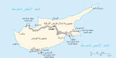
Arabic
File history
Click on a date/time to view the file as it appeared at that time.
| Date/Time | Thumbnail | Dimensions | User | Comment | |
|---|---|---|---|---|---|
| current | 20:30, 27 November 2004 |  | 629 × 319 (12 KB) | Kneiphof (talk | contribs) | CIA Cyprus map |
You cannot overwrite this file.
File usage on Commons
The following 2 pages use this file:
File usage on other wikis
The following other wikis use this file:
- Usage on azb.wikipedia.org
- Usage on be.wikipedia.org
- Usage on ca.wikipedia.org
- Usage on ckb.wikipedia.org
- Usage on cs.wikinews.org
- Usage on de.wikipedia.org
- Usage on dsb.wikipedia.org
- Usage on en.wikipedia.org
- Cyprus
- Turkish invasion of Cyprus
- Greek junta
- Portal:Cyprus
- Greek New Zealanders
- United Nations Security Council Resolution 370
- United Nations Security Council Resolution 383
- United Nations Security Council Resolution 391
- United Nations Security Council Resolution 401
- United Nations Security Council Resolution 410
- United Nations Security Council Resolution 422
- United Nations Security Council Resolution 430
- United Nations Security Council Resolution 440
- United Nations Security Council Resolution 443
- Category:Populated places in Cyprus
- File talk:Cy-map.png
- Talk:Grand Lodge of Cyprus
- Usage on en.wikivoyage.org
- Usage on eo.wikipedia.org
- Usage on fa.wikipedia.org
- Usage on fr.wikipedia.org
- Résolution 370 du Conseil de sécurité des Nations unies
- Résolution 383 du Conseil de sécurité des Nations unies
- Résolution 391 du Conseil de sécurité des Nations unies
- Résolution 401 du Conseil de sécurité des Nations unies
- Résolution 410 du Conseil de sécurité des Nations unies
- Résolution 422 du Conseil de sécurité des Nations unies
View more global usage of this file.


